
Datei:MapaSageo-Guayas-02.png
Größe dieser Vorschau: 433 × 599 Pixel. Weitere Auflösungen: 173 × 240 Pixel | 347 × 480 Pixel | 702 × 971 Pixel
Originaldatei (702 × 971 Pixel, Dateigröße: 55 KB, MIME-Typ: image/png)
![]()
Diese Datei und die Informationen unter dem roten Trennstrich werden aus dem zentralen Medienarchiv Wikimedia Commons eingebunden.
![]()
Beschreibung
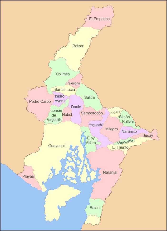
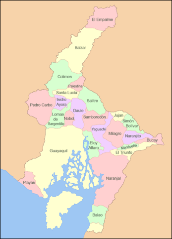
| Beschreibung | Español: Mapa de los cantones de la Provincia del Guayas |
| Datum | |
| Quelle | Eigenes Werk |
| Urheber | Sageo |
Lizenz
Ich, der Urheberrechtsinhaber dieses Werkes, veröffentliche es hiermit unter der folgenden Lizenz:
 | Es ist erlaubt, die Datei unter den Bedingungen der GNU-Lizenz für freie Dokumentation, Version 1.2 oder einer späteren Version, veröffentlicht von der Free Software Foundation, zu kopieren, zu verbreiten und/oder zu modifizieren; es gibt keine unveränderlichen Abschnitte, keinen vorderen und keinen hinteren Umschlagtext. Der vollständige Text der Lizenz ist im Kapitel GNU-Lizenz für freie Dokumentation verfügbar. |
Diese Datei ist unter den Creative Commons-Lizenzen Namensnennung – Weitergabe unter gleichen Bedingungen 4.0 International, 3.0 nicht portiert, 2.5 Allgemein, 2.0 Allgemein und 1.0 Allgemein lizenziert.
- Dieses Werk darf von dir
- verbreitet werden – vervielfältigt, verbreitet und öffentlich zugänglich gemacht werden
- neu zusammengestellt werden – abgewandelt und bearbeitet werden
- Zu den folgenden Bedingungen:
- Namensnennung – Du musst angemessene Urheber- und Rechteangaben machen, einen Link zur Lizenz beifügen und angeben, ob Änderungen vorgenommen wurden. Diese Angaben dürfen in jeder angemessenen Art und Weise gemacht werden, allerdings nicht so, dass der Eindruck entsteht, der Lizenzgeber unterstütze gerade dich oder deine Nutzung besonders.
- Weitergabe unter gleichen Bedingungen – Wenn du das Material wiedermischst, transformierst oder darauf aufbaust, musst du deine Beiträge unter der gleichen oder einer kompatiblen Lizenz wie das Original verbreiten.
Du darfst es unter einer der obigen Lizenzen deiner Wahl verwenden.
Dateiversionen
Klicke auf einen Zeitpunkt, um diese Version zu laden.
| Version vom | Vorschaubild | Maße | Benutzer | Kommentar | |
|---|---|---|---|---|---|
| aktuell | 07:22, 5. Mär. 2009 | | 702 × 971 (55 KB) | Sageo | {{Information |Description={{es|1=Mapa de los cantones de la Provincia del Guayas}} |Source=trabajo propio (own work) |Author=Sageo |Date=5 de marzo de 2009 |Permission= |other_versions= }} <!--{{ImageUpload|full}}--> Category:Guayas |
Dateiverwendung
Die folgenden 2 Seiten verwenden diese Datei:
Globale Dateiverwendung
Die nachfolgenden anderen Wikis verwenden diese Datei:
- Verwendung auf ar.wikipedia.org
- Verwendung auf arz.wikipedia.org
- Verwendung auf ca.wikipedia.org
- Verwendung auf ceb.wikipedia.org
- Verwendung auf cs.wikipedia.org
- Verwendung auf en.wikipedia.org
- Guayas Province
- Pedro Carbo
- Guayaquil Canton
- Naranjal Canton
- Alfredo Baquerizo Moreno Canton
- Balao Canton
- El Empalme Canton
- El Triunfo Canton
- General Antonio Elizalde Canton
- Isidro Ayora Canton
- Lomas de Sargentillo Canton
- Milagro Canton
- Naranjito Canton
- Palestina Canton
- Pedro Carbo Canton
- Playas Canton
- Samborondón Canton
- Santa Lucía Canton
- Simón Bolívar Canton
- Yaguachi Canton
- Verwendung auf es.wikipedia.org
- Verwendung auf eu.wikipedia.org
- Verwendung auf fa.wikipedia.org
- Verwendung auf id.wikipedia.org
- Verwendung auf incubator.wikimedia.org
Weitere globale Verwendungen dieser Datei anschauen.


