| Name
|
Region
|
Gewässer
|
Position
|
Baujahr
|
Turmhöhe
|
Feuerhöhe
|
Kennung
|
Bild
|
| Anvil Point Lighthouse
|
Dorset
|
Ärmelkanal
|
50° 35′ 30,7″ N, 1° 57′ 35,6″ W50.59187-1.95989
|
1881
|
12 m
|
45 m
|
Fl.W.10s
|

|
| Bamburgh Lighthouse
|
Northumberland
|
Nordsee
|
55° 36′ 59,5″ N, 1° 43′ 27,2″ W55.61652-1.72423
|
1910
|
9 m
|
13 m
|
Oc(2)WRG.8s
|

|
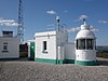
| Beach Lighthouse (Fleetwood)
|
Lancashire
|
Morecambe Bay
|
53° 55′ 42,8″ N, 3° 0′ 32,7″ W53.92855-3.00907
|
1840
|
13 m
|
14 m
|
Fl.G.2s
|

|
| Beachy Head Lighthouse
|
East Sussex
|
Ärmelkanal
|
50° 44′ 1,3″ N, 0° 14′ 29,3″ O50.73370.24148
|
1902
|
33 m
|
31 m
|
Fl(2)W.20s
|

|
| Berry Head Lighthouse
|
Devon
|
Ärmelkanal
|
50° 23′ 58,5″ N, 3° 29′ 0,3″ W50.39958-3.48343
|
1906
|
5 m
|
58 m
|
Fl(2)W.15s
|
|
| Bishop Rock Lighthouse
|
Scilly-Inseln
|
Keltische See
|
49° 52′ 22,3″ N, 6° 26′ 44,1″ W49.87285-6.44557
|
1858
1887
|
49 m
|
44 m
|
Fl(2)W.15s
|

|
| Bow Creek Lighthouse
|
London
|
Themse
|
51° 30′ 27,6″ N, 0° 0′ 29,8″ O51.507680.00829
|
1866
|
unbekannt
|
unbekannt
|
gelöscht (1988)
|
|
| Bull Point Lighthouse
|
Devon
|
Bristolkanal
|
51° 11′ 56,7″ N, 4° 12′ 4,2″ W51.19909-4.20118
|
1975
|
11 m
|
54 m
|
Fl(3)W.10s
|

|
| Coquet Lighthouse
|
Northumberland
|
Nordsee
|
55° 20′ 2,2″ N, 1° 32′ 21,7″ W55.33395-1.53937
|
1841
|
22 m
|
25 m
|
Fl(3)WR.20s
|
|
| Cromer Lighthouse
|
Norfolk
|
Nordsee
|
52° 55′ 28,9″ N, 1° 18′ 59,4″ O52.92471.3165
|
1833
|
18 m
|
84 m
|
Fl.W.5s
|

|
| Crow Point Lighthouse
|
Devon
|
Bristolkanal
|
51° 3′ 58,1″ N, 4° 11′ 23,4″ W51.06615-4.18982
|
1954
|
5 m
|
8 m
|
Fl.WR.2.5s
|

|
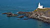
| Dungeness Lighthouse
|
Kent
|
Straße von Dover
|
50° 54′ 48,4″ N, 0° 58′ 33,3″ O50.913450.97592
|
1961
|
43 m
|
40 m
|
Fl.W.10s
|

|
| Eddystone Lighthouse
|
Devon
|
Ärmelkanal
|
50° 10′ 50,6″ N, 4° 15′ 56,2″ W50.18072-4.2656
|
1882
|
49 m
|
41 m
|
Fl(2)W.10s
|
|
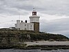
| Farne Island Lighthouse
|
Northumberland
|
Nordsee
|
55° 36′ 55,2″ N, 1° 39′ 20,3″ W55.61533-1.65564
|
1811
|
13 m
|
27 m
|
Fl(2)WR.15s
|

|
| Flamborough Head Lighthouse
|
East Riding of Yorkshire
|
Nordsee
|
54° 6′ 58,9″ N, 0° 4′ 57,6″ W54.11637-0.08267
|
1806
|
27 m
|
65 m
|
Fl(4)W.15s
|

|
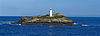
| Godrevy Lighthouse
|
Cornwall
|
Keltische See
|
50° 14′ 32,8″ N, 5° 24′ 1,4″ W50.24245-5.4004
|
1859
|
26 m
|
28 m
|
Fl.WR.10s
|
|
| Guile Point Lighthouse
|
Northumberland
|
Nordsee
|
55° 39′ 29,4″ N, 1° 47′ 35,5″ W55.65817-1.7932
|
1859
|
21 m
|
9 m
|
Oc.WRG.6s
|

|
| Hartland Point Lighthouse
|
Devon
|
Keltische See
|
51° 1′ 19,1″ N, 4° 31′ 31,4″ W51.02197-4.52538
|
1874
|
18 m
|
37 m
|
Fl(6)W.15s
|
|
| Heugh Hill Lighthouse
|
Northumberland
|
Nordsee
|
55° 40′ 5,5″ N, 1° 47′ 58,4″ W55.6682-1.79956
|
1826
|
8 m
|
24 m
|
Oc.WRG.6s
|

|
| Hilbre Island Lighthouse
|
Merseyside
|
Irische See
|
53° 22′ 59,3″ N, 3° 13′ 42,8″ W53.38315-3.22856
|
1927
|
3 m
|
14 m
|
Fl.R.3s
|

|
| Hurst Point Lighthouse
|
Hampshire
|
Solent
|
50° 42′ 28,6″ N, 1° 33′ 1,2″ W50.70795-1.55033
|
1867
|
26 m
|
23 m
|
Fl(4)WR.15s
Dir.Iso.WRG.4s
|
|
| Lizard Lighthouse
|
Cornwall
|
Ärmelkanal
|
49° 57′ 36,7″ N, 5° 12′ 7,6″ W49.9602-5.20212
|
1751
|
19 m
|
70 m
|
Fl.W.3s
|

|
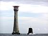
| Longships Lighthouse
|
Cornwall
|
Keltische See
|
50° 4′ 0,7″ N, 5° 44′ 48,4″ W50.06687-5.74677
|
1875
|
35 m
|
35 m
|
Fl(2)WR.10s
|

|
| Longstone Lighthouse
|
Northumberland
|
Nordsee
|
55° 38′ 37,5″ N, 1° 36′ 39″ W55.64375-1.61082
|
1826
|
26 m
|
23 m
|
Fl.W.20s
|

|
| Lowestoft Lighthouse
|
Suffolk
|
Nordsee
|
52° 29′ 13,1″ N, 1° 45′ 21,2″ O52.486981.7559
|
1874
|
16 m
|
37 m
|
Fl.W.15s
|

|
| Lundy North Lighthouse
|
Devon
|
Bristolkanal
|
51° 12′ 6,2″ N, 4° 40′ 38,2″ W51.20173-4.67728
|
1897
|
17 m
|
48 m
|
Fl.W.15s
|

|
| Lundy Old Lighthouse
|
Devon
|
Bristolkanal
|
51° 10′ 2″ N, 4° 40′ 24,1″ W51.16721-4.67337
|
1820
|
29 m
|
164 m
|
gelöscht (1897)
|

|
| Lundy South Lighthouse
|
Devon
|
Bristolkanal
|
51° 9′ 43,4″ N, 4° 39′ 20,9″ W51.16205-4.6558
|
1897
|
16 m
|
53 m
|
Fl.W.5s
|

|
| Lynmouth Foreland Lighthouse
|
Devon
|
Bristolkanal
|
51° 14′ 43,6″ N, 3° 47′ 10,7″ W51.24545-3.7863
|
1900
|
15 m
|
67 m
|
Fl(4)W.15s
|

|
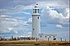
| Nab Tower Lighthouse
|
Isle of Wight
|
Solent
|
50° 40′ 4,5″ N, 0° 57′ 9,3″ W50.66792-0.95258
|
1918
|
17 m
|
17 m
|
Fl.W.10s
|

|
| Needles Lighthouse
|
Isle of Wight
|
Solent
|
50° 39′ 44″ N, 1° 35′ 30,3″ W50.66223-1.59175
|
1859
|
31 m
|
24 m
|
Oc(2)WRG.20s
|

|
| Pendeen Lighthouse
|
Cornwall
|
Keltische See
|
50° 9′ 53,9″ N, 5° 40′ 17,7″ W50.16497-5.67159
|
1900
|
17 m
|
59 m
|
Fl(4)W.15s
|

|
| Peninnis Lighthouse
|
Scilly-Inseln
|
Keltische See
|
49° 54′ 16,7″ N, 6° 18′ 12,8″ W49.90463-6.30355
|
1911
|
14 m
|
36 m
|
Fl.W.20s
|

|
| Pharos Lighthouse (Fleetwood)
|
Lancashire
|
Morecambe Bay
|
53° 55′ 35,4″ N, 3° 0′ 27″ W53.92651-3.00751
|
1840
|
27 m
|
28 m
|
Fl.G.4s
|

|
| Plover Scar Lighthouse
|
Lancashire
|
Morecambe Bay
|
53° 58′ 53,4″ N, 2° 52′ 57,3″ W53.98151-2.88259
|
1847
|
8 m
|
6 m
|
Fl.W.2s
|

|
| Portland Bill Lighthouse
|
Dorset
|
Ärmelkanal
|
50° 30′ 50,8″ N, 2° 27′ 23,1″ W50.51411-2.45641
|
1906
|
41 m
|
43 m
|
Fl(4)W.20s
|

|
| Round Island Lighthouse
|
Scilly-Inseln
|
Keltische See
|
49° 58′ 44,4″ N, 6° 19′ 22,6″ W49.979-6.32295
|
1887
|
19 m
|
55 m
|
Fl.W.10s
|

|
| Royal Sovereign Lighthouse
|
East Sussex
|
Ärmelkanal
|
50° 43′ 27,2″ N, 0° 26′ 5,2″ O50.724230.43477
|
1971
|
36 m
|
28 m
|
Fl.W.20s
|

|
| Smeaton's Tower
|
Devon
|
Plymouth Sound
|
50° 21′ 51,7″ N, 4° 8′ 30,9″ W50.36435-4.14192
|
1759
|
22 m
|
unbekannt
|
gelöscht (1877)
|

|
| Southwold Lighthouse
|
Suffolk
|
Nordsee
|
52° 19′ 37,9″ N, 1° 40′ 52,8″ O52.32721.68134
|
1887
|
31 m
|
37 m
|
Fl.W.10s
|

|
| St. Anthony Lighthouse
|
Cornwall
|
Ärmelkanal
|
50° 8′ 28,1″ N, 5° 0′ 58″ W50.14115-5.01612
|
1835
|
19 m
|
22 m
|
Iso.WR.15s
|

|
| St Bees Lighthouse
|
Cumbria
|
Solway Firth
|
54° 30′ 49,1″ N, 3° 38′ 12″ W54.51365-3.63668
|
1822
|
17 m
|
102 m
|
Fl(2)W.20s
|

|
| St. Catherine′s Lighthouse
|
Isle of Wight
|
Ärmelkanal
|
50° 34′ 32,2″ N, 1° 17′ 52,4″ W50.57561-1.2979
|
1838
|
27 m
|
41 m
|
Fl.W.5s
|

|
| St. Mary’s Lighthouse
|
Tyne and Wear
|
Nordsee
|
55° 4′ 18,1″ N, 1° 26′ 58,1″ W55.07169-1.44947
|
1898
|
46 m
|
unbekannt
|
gelöscht (1984)
|

|
| Start Point Lighthouse
|
Devon
|
Ärmelkanal
|
50° 13′ 21,2″ N, 3° 38′ 32,1″ W50.22255-3.64225
|
1836
|
28 m
|
62 m
|
Fl(3)W.10s
|

|
| Tater Du Lighthouse
|
Cornwall
|
Ärmelkanal
|
50° 3′ 8,6″ N, 5° 34′ 38,8″ W50.0524-5.57745
|
1965
|
15 m
|
34 m
|
Fl(3)W.15s
|

|
| Trevose Head Lighthouse
|
Cornwall
|
Keltische See
|
50° 32′ 57,2″ N, 5° 2′ 6,7″ W50.54923-5.0352
|
1847
|
27 m
|
62 m
|
Fl.W.7.5s
|

|
| Whitby Lighthouse
|
Yorkshire
|
Nordsee
|
54° 28′ 40,2″ N, 0° 34′ 5,7″ W54.47783-0.56826
|
1858
|
13 m
|
73 m
|
Fl.WR.5s
|

|
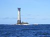
| Wolf Rock Lighthouse
|
Cornwall
|
Keltische See
|
49° 56′ 43,2″ N, 5° 48′ 33″ W49.94532-5.80917
|
1869
|
41 m
|
34 m
|
Fl.W.15s
|
|
| Wyre Light
|
Lancashire
|
Morecambe Bay
|
53° 57′ 9,1″ N, 3° 1′ 47,9″ W53.95252-3.02997
|
1840
|
5 m
|
14 m
|
gelöscht (1979)
|

|


