
Provinz Mashonaland Central
| Mashonaland Central Provinz Mashonaland Central | |
|---|---|
 | |
| Basisdaten | |
| Staat | Simbabwe |
| Hauptstadt | Bindura |
| Fläche | 28.195 km² |
| Einwohner | 1.384.891 (2022) |
| Dichte | 49 Einwohner pro km² |
| ISO 3166-2 | ZW-MC |
Koordinaten: 17° 0′ S, 31° 0′ O
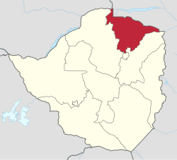
Mashonaland Central (deutsch Zentralmaschonaland) ist eine Provinz im Nordosten Simbabwes. Sie ist 28.195 km² groß und beheimatet 1.384.891 (2022) Einwohner.[1] 2012 lebten etwa 8,8 Prozent der Gesamtbevölkerung des Landes in der Provinz. Bindura ist die Hauptstadt der Provinz.
Geographie
| Provinz Lusaka, Sambia | Provinz Tete, Mosambik | Provinz Tete, Mosambik |
| Mashonaland West |  | Mashonaland East |
| Mashonaland West | Mashonaland East/ Harare | Mashonaland East |
Distrikte

Mashonaland Central besteht aus zehn Distrikten (Stand 2022):[2]
| Distrikt | Fläche in [km²] | Einwohner 2012[3] | Einwohner 2022 | Bevölkerungsdichte 2022 [Einwohner/km²] |
|---|---|---|---|---|
| Bindura Rural[4] | 2242 | 125.219 | 169.841 | 76 |
| Bindura Urban | 20 | 43.675 | 51.394 | 2574 |
| Guruve | 2994 | 124.041 | 153.606 | 51 |
| Mazowe | 4354 | 233.450 | 293.363 | 67 |
| Mbire | 4696 | 82.380 | 83.720 | 18 |
| Mount Darwin | 4596 | 212.725 | 240.728 | 52 |
| Muzarabani (Centenary) | 4266 | 122.791 | 134.076 | 31 |
| Mvurwi | 3 | 10.549 | 15.646 | 5652 |
| Rushinga | 2328 | 74.040 | 76.876 | 33 |
| Shamva | 2695 | 123.650 | 165.641 | 61 |
| Gesamt | 56.456 | 1.485.090 | 1.638.528 | 29 |
Weblinks
Commons: Provinz Mashonaland Central – Sammlung von Bildern, Videos und Audiodateien
Einzelnachweise
- ↑ Statistisches Amt Simbabwe, Seite 6
- ↑ Zimbabwe 2022 Population and Housing Census Report, Volume 2 Population Distribution by Ward. Zimbabwe National Statistics Agency. S. 15–25 (englisch, PDF).
- ↑ 2012 Population Census
- ↑ Bindura Rural District Council: Webpräsenz. auf www.bindurardc.co.zw (englisch).


