
Datei:NPS congaree-map.jpg

Größe dieser Vorschau: 800 × 535 Pixel. Weitere Auflösungen: 320 × 214 Pixel | 640 × 428 Pixel | 1.024 × 685 Pixel | 1.426 × 954 Pixel
Originaldatei (1.426 × 954 Pixel, Dateigröße: 289 KB, MIME-Typ: image/jpeg)
![]()
Diese Datei und die Informationen unter dem roten Trennstrich werden aus dem zentralen Medienarchiv Wikimedia Commons eingebunden.
![]()
Beschreibung
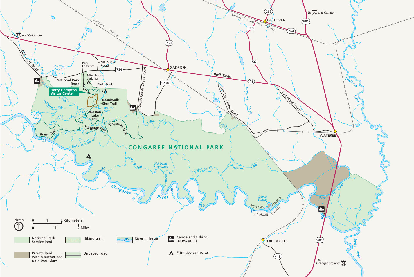
| Beschreibung | English: Official Congaree National Park map from the brochure, showing the visitor center, trails, roads, and campsites. |
| Datum | |
| Quelle | U.S. National Park Service (http://npmaps.com/wp-content/uploads/congaree-map.jpg) |
| Urheber | U.S. National Park Service, restoration/cleanup by Matt Holly |
| Andere Versionen |  |
Lizenz
| Diese Datei ist ein Werk eines Mitarbeiters des National Park Service (NPS) der Vereinigten Staaten, aufgenommen oder hergestellt während seiner offiziellen Anstellung. Als ein amtliches Werk der Bundesregierung der Vereinigten Staaten ist dieses Bild gemeinfrei. (Nähere Informationen dazu sind auf der offiziellen Website des NPS verfügbar.) |
Dateiversionen
Klicke auf einen Zeitpunkt, um diese Version zu laden.
| Version vom | Vorschaubild | Maße | Benutzer | Kommentar | |
|---|---|---|---|---|---|
| aktuell | 22:08, 16. Mai 2017 | | 1.426 × 954 (289 KB) | RKBot | =={{int:filedesc}}== {{Information |description= {{en|1=Official Congaree National Park map from the brochure, showing the visitor center, trails, roads, and campsites.}} |date= 2016-01-24 |source= U.S. National Park Service (http://npmaps.com/wp-conte... |
Dateiverwendung
Die folgende Seite verwendet diese Datei:
Globale Dateiverwendung
Die nachfolgenden anderen Wikis verwenden diese Datei:
- Verwendung auf he.wikipedia.org


