
Datei:Iwate - Miyako - Taro-Mukaishinden -a- Tsunami height -b- View of damage -c- The survey point where the tsunami runup height of 37,8 m was measured.jpg

Größe dieser Vorschau: 727 × 599 Pixel. Weitere Auflösungen: 291 × 240 Pixel | 582 × 480 Pixel | 932 × 768 Pixel | 1.242 × 1.024 Pixel | 2.069 × 1.706 Pixel
Originaldatei (2.069 × 1.706 Pixel, Dateigröße: 691 KB, MIME-Typ: image/jpeg)
![]()
Diese Datei und die Informationen unter dem roten Trennstrich werden aus dem zentralen Medienarchiv Wikimedia Commons eingebunden.
![]()
Beschreibung
| Beschreibung |
English: Source: Yoshinobu Tsuji, Kenji Satake, Takeo Ishibe, Tomoya Harada, Akihito Nishiyama, Satoshi Kusumoto: "Tsunami Heights along the Pacific Coast of Northern Honshu Recorded from the 2011 Tohoku", Pure and Applied Geophysics, 171, 12, (2014), pp. 3183–3215, DOI:10.1007/s00024-014-0779-x, online published on 19 March 2014. License: Creative Commons Attribution 4.0 International (CC BY 4.0). Here p. 3188, Figure 5.
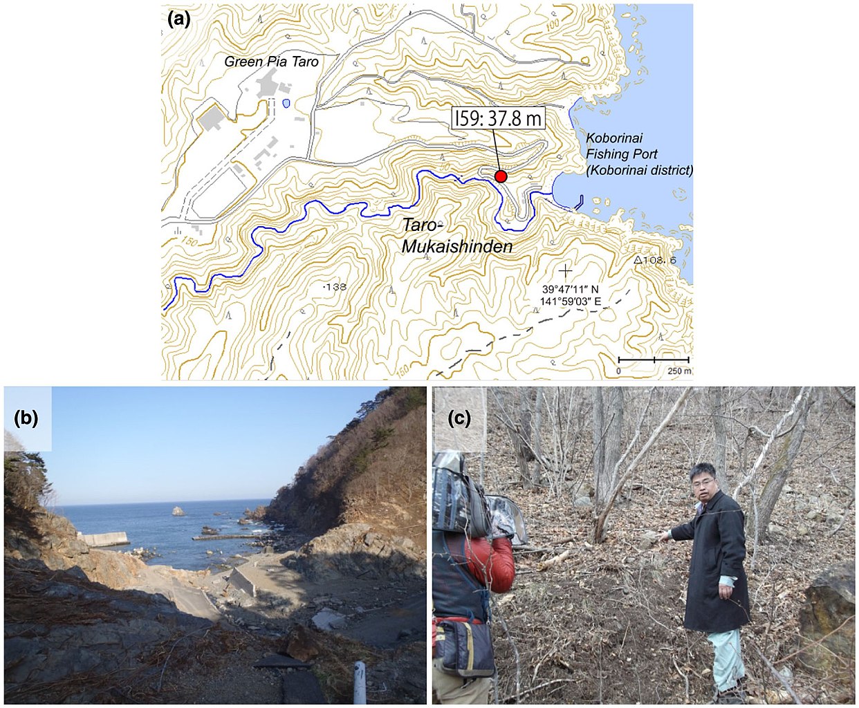
Caption as given in the above cited source: "Figure 5 - a Tsunami height at Taro-Mukaishinden, Miyako City, Iwate Prefecture. The symbol and its meaning are the same as in Fig. 3. b View of tsunami damage at Taro-Mukaishinden. The white pole in the lower-right of the picture was bent by the tsunami. c The survey point where the largest tsunami runup height of 37.8 m in our field surveys was measured"
|
| Datum | |
| Quelle | Yoshinobu Tsuji, Kenji Satake, Takeo Ishibe, Tomoya Harada, Akihito Nishiyama, Satoshi Kusumoto: "Tsunami Heights along the Pacific Coast of Northern Honshu Recorded from the 2011 Tohoku", Pure and Applied Geophysics, 171, 12, (2014), pp. 3183–3215, DOI:10.1007/s00024-014-0779-x, online published on 19 March 2014. License: Creative Commons Attribution 4.0 International (CC BY 4.0). Here p. 3188, Figure 5. |
| Urheber | Yoshinobu Tsuji, Kenji Satake, Takeo Ishibe, Tomoya Harada, Akihito Nishiyama, Satoshi Kusumoto: "Tsunami Heights along the Pacific Coast of Northern Honshu Recorded from the 2011 Tohoku", Pure and Applied Geophysics, 171, 12, (2014), pp. 3183–3215, DOI:10.1007/s00024-014-0779-x, online published on 19 March 2014. License: Creative Commons Attribution 4.0 International (CC BY 4.0). Here p. 3188, Figure 5. |
| Genehmigung (Weiternutzung dieser Datei) |
Diese Datei ist lizenziert unter der Creative-Commons-Lizenz „Namensnennung 4.0 international“.
|
Lizenz
Diese Datei ist lizenziert unter der Creative-Commons-Lizenz „Namensnennung 4.0 international“.
- Dieses Werk darf von dir
- verbreitet werden – vervielfältigt, verbreitet und öffentlich zugänglich gemacht werden
- neu zusammengestellt werden – abgewandelt und bearbeitet werden
- Zu den folgenden Bedingungen:
- Namensnennung – Du musst angemessene Urheber- und Rechteangaben machen, einen Link zur Lizenz beifügen und angeben, ob Änderungen vorgenommen wurden. Diese Angaben dürfen in jeder angemessenen Art und Weise gemacht werden, allerdings nicht so, dass der Eindruck entsteht, der Lizenzgeber unterstütze gerade dich oder deine Nutzung besonders.
Dateiversionen
Klicke auf einen Zeitpunkt, um diese Version zu laden.
| Version vom | Vorschaubild | Maße | Benutzer | Kommentar | |
|---|---|---|---|---|---|
| aktuell | 13:31, 16. Aug. 2018 | | 2.069 × 1.706 (691 KB) | Anglo-Araneophilus~commonswiki | {{Information |description ={{en|1=Source: Yoshinobu Tsuji, Kenji Satake, Takeo Ishibe, Tomoya Harada, Akihito Nishiyama, Satoshi Kusumoto: "Tsunami Heights along the Pacific Coast of Northern Honshu Recorded from the 2011 Tohoku", Pure and Applied Geophysics, 171, 12, (2014), pp. 3183–3215, DOI:10.1007/s00024-014-0779-x, online published on 19 March 2014. License: Creative Commons Attribution 4.0 International (CC BY 4.0). Here p. 3188, Figure 5. Caption as given in the above cited source... |
Dateiverwendung
Die folgende Seite verwendet diese Datei:


