
Datei:HMSO Graf Spee map of River Plate.jpg
Es ist keine höhere Auflösung vorhanden.
HMSO_Graf_Spee_map_of_River_Plate.jpg (751 × 517 Pixel, Dateigröße: 57 KB, MIME-Typ: image/jpeg)
![]()
Diese Datei und die Informationen unter dem roten Trennstrich werden aus dem zentralen Medienarchiv Wikimedia Commons eingebunden.
![]()
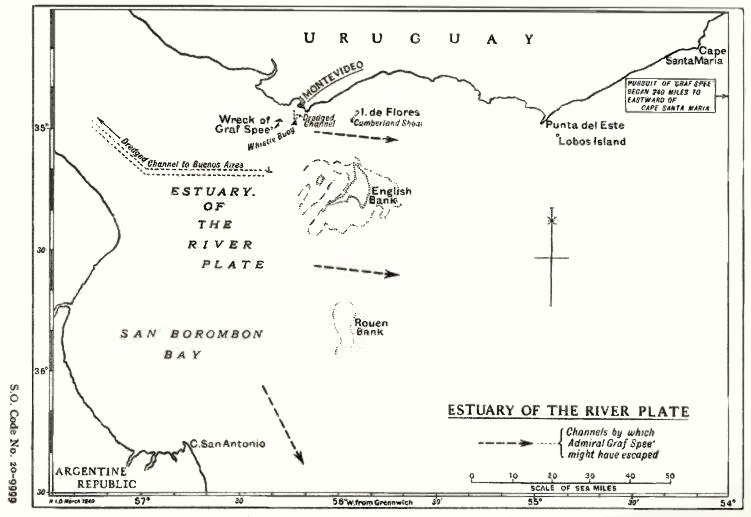
| Beschreibung | Map of the estuary of the River Plate showing possible exit channels available to the German heavy cruiser Admiral Graf Spee after the Battle of the River Plate in December 1939. | |||
| Datum | ||||
| Quelle | From official British report into the cruise of the Graf Spee and Battle of the River Plate. Published by HMSO (His Majesty's Stationery Office). Originally uploaded to EN Wikipedia as en:File:HMSO Graf Spee map of River Plate.jpg by en:User:Duncharris 26 December 2004; modified by en:User:Lhgodoy 22 March 2006. | |||
| Urheber | British Government | |||
| Genehmigung (Weiternutzung dieser Datei) | Crown Copyright expired (50 years)
| |||
| Andere Versionen | en:File:HMSO Graf Spee map of River Plate.jpg |

Dateiversionen
Klicke auf einen Zeitpunkt, um diese Version zu laden.
| Version vom | Vorschaubild | Maße | Benutzer | Kommentar | |
|---|---|---|---|---|---|
| aktuell | 19:05, 20. Dez. 2009 | | 751 × 517 (57 KB) | Rcbutcher | {{Information |Description=Map of the estuary of the River Plate showing possible exit channels available to the German heavy cruiser Admiral Graf Spee after the Battle of the River Plate in December 1939. |Source=From official British report into the cru |
Dateiverwendung
Die folgende Seite verwendet diese Datei:
Globale Dateiverwendung
Die nachfolgenden anderen Wikis verwenden diese Datei:
- Verwendung auf azb.wikipedia.org
- Verwendung auf ca.wikipedia.org
- Verwendung auf en.wikipedia.org
- Verwendung auf es.wikipedia.org
- Verwendung auf hu.wikipedia.org
- Verwendung auf it.wikipedia.org
- Verwendung auf nl.wikipedia.org


