
„Vorlage:Imagemap CostaRica1“ – Versionsunterschied
| [gesichtete Version] | [gesichtete Version] |
Inhalt gelöscht Inhalt hinzugefügt
KKeine Bearbeitungszusammenfassung |
negative zahlen raus |
||
| Zeile 5: | Zeile 5: | ||
poly 61 |
poly 61 0 176 112 203 112 223 69 252 77 286 98 404 142 467 102 525 136 548 126 569 154 588 164 589 185 624 183 638 178 651 193 719 177 716 134 688 50 710 1 [[Nicaragua]] |
||
poly 1146 591 1134 583 1134 558 1107 537 1068 513 1009 492 994 506 986 517 950 489 931 488 929 512 932 518 909 530 915 623 919 622 959 652 967 665 928 690 918 705 926 726 933 767 931 790 880 818 906 829 914 852 922 905 943 886 954 837 998 836 1044 875 1077 905 1128 876 1117 921 1145 927 [[Panama]] |
poly 1146 591 1134 583 1134 558 1107 537 1068 513 1009 492 994 506 986 517 950 489 931 488 929 512 932 518 909 530 915 623 919 622 959 652 967 665 928 690 918 705 926 726 933 767 931 790 880 818 906 829 914 852 922 905 943 886 954 837 998 836 1044 875 1077 905 1128 876 1117 921 1145 927 [[Panama]] |
||
poly 132 170 149 142 185 115 204 111 224 72 246 80 250 88 322 110 289 140 271 146 312 189 346 192 387 216 396 239 426 250 443 277 439 316 423 301 416 314 415 337 409 352 400 357 370 339 351 340 351 343 329 357 335 383 333 397 319 401 317 411 325 422 328 432 329 447 328 456 321 458 298 451 271 436 228 426 194 412 154 369 139 329 148 274 179 224 190 203 149 181 138 169 [[Provinz Guanacaste]] |
poly 132 170 149 142 185 115 204 111 224 72 246 80 250 88 322 110 289 140 271 146 312 189 346 192 387 216 396 239 426 250 443 277 439 316 423 301 416 314 415 337 409 352 400 357 370 339 351 340 351 343 329 357 335 383 333 397 319 401 317 411 325 422 328 432 329 447 328 456 321 458 298 451 271 436 228 426 194 412 154 369 139 329 148 274 179 224 190 203 149 181 138 169 [[Provinz Guanacaste]] |
||
| Zeile 21: | Zeile 18: | ||
}}<noinclude> |
}}<noinclude> |
||
Diese Vorlage erzeugt eine [[Verweissensitive Grafik|anklickbare Karte]] (eine sogenannte [[Hilfe:Bilder#Imagemaps|Imagemap]]). |
Diese Vorlage erzeugt eine [[Verweissensitive Grafik|anklickbare Karte]] (eine sogenannte [[Hilfe:Bilder#Imagemaps|Imagemap]]). |
||
Aktuelle Version vom 29. März 2019, 20:44 Uhr
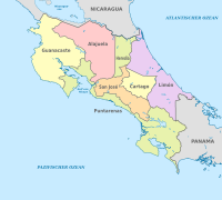
Diese Vorlage erzeugt eine anklickbare Karte (eine sogenannte Imagemap).
Verwendung:
{{Imagemap CostaRica1|Bild.svg}}
{{Imagemap CostaRica1|Bild.svg|left|281px}}
Es dürfen nur Bilder mit einer dem obigen Bild entsprechenden Basisgröße eingesetzt werden.
Für die Verwendung in Infoboxen (experimentell):
{{Imagemap CostaRica1|Bild=…|Maße=left{{!}}299px|Alt=…}}


