| [1] | Name | Bild | Eintragsdatum | Lage | Ort | Beschreibung |
|---|
| 1 | 35-CS-130-The Osprey Site | | 6. März 2001
ID-Nr. 01000131 | Adresse nicht veröffentlicht
| North Bend | |
|---|
| 2 | Edwin and Ethel Abernethy House |  Edwin and Ethel Abernethy House Edwin and Ethel Abernethy House | 22. Sep. 1988
ID-Nr. 88001532 | Box 103, Sitkum Route
43° 9′ 28,2″ N, 123° 57′ 42,2″ W43.157837-123.96173 | Myrtle Point (Umgebung) | |
|---|
| 3 | Archeological Site 35CS129 | | 10. Sep. 1997
ID-Nr. 97001031 | Adresse nicht veröffentlicht
| Charleston | |
|---|
| 4 | Archeological Site 35CS24 | | 10. Sep. 1997
ID-Nr. 97001029 | Adresse nicht veröffentlicht
| North Bend | |
|---|
| 5 | Archeological Site 35CS39 | | 10. Sep. 1997
ID-Nr. 97001036 | Adresse nicht veröffentlicht
| Charleston | |
|---|
| 6 | Archeological Site 35CS66 | | 10. Sep. 1997
ID-Nr. 97001034 | Adresse nicht veröffentlicht
| Charleston | |
|---|
| 7 | Archeological Site 35CS67 | | 10. Sep. 1997
ID-Nr. 97001033 | Adresse nicht veröffentlicht
| Charleston | |
|---|
| 8 | Archeological Site 35CS8 | | 10. Sep. 1997
ID-Nr. 97001040 | Adresse nicht veröffentlicht
| Bandon | |
|---|
| 9 | Archeological Site 35CS9 | | 10. Sep. 1997
ID-Nr. 97001039 | Adresse nicht veröffentlicht
| Bandon | |
|---|
| 10 | A. H. Black and Company Building |  A. H. Black and Company Building A. H. Black and Company Building | 25. Okt. 1990
ID-Nr. 90001586 | 531 Spruce St.
43° 3′ 54,5″ N, 124° 8′ 27,8″ W43.065125-124.141042 | Myrtle Point | |
|---|
| 11 | Breuer Building | 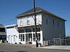 Breuer Building Breuer Building | 2. Okt. 1992
ID-Nr. 92001308 | 460 1st Street SW
43° 7′ 14,7″ N, 124° 25′ 6″ W43.120748-124.418334 | Bandon | |
|---|
| 12 | Bullards Beach Site | | 10. Sep. 1997
ID-Nr. 97001037 | Adresse nicht veröffentlicht
| Bandon | |
|---|
| 13 | Cape Arago Lighthouse |  Cape Arago Lighthouse Cape Arago Lighthouse
weitere Bilder | 13. Mai 1993
ID-Nr. 73002338 | Gregory Point, nördlich von Cape Arago und ca. 3,2 km südwestlich der Grenze von Coos Bay
43° 20′ 28,5″ N, 124° 22′ 31,2″ W43.341248-124.37533 | Charleston | |
|---|
| 14 | Cape Arago Site (35CS10) |  Cape Arago Site (35CS10) Cape Arago Site (35CS10) | 10. Sep. 1997
ID-Nr. 97001035 | Adresse nicht veröffentlicht
| Charleston | |
|---|
| 15 | Leo J. Cary House |  Leo J. Cary House Leo J. Cary House | 14. Okt. 1992
ID-Nr. 92001317 | 572 E. 1st St.
43° 10′ 30,3″ N, 124° 10′ 58,7″ W43.175076-124.182981 | Coquille | |
|---|
| 16 | Chandler Hotel and Annex |  Chandler Hotel and Annex Chandler Hotel and Annex | 14. Juni 1984
ID-Nr. 84002966 | 187 Central Ave.
43° 22′ 3,9″ N, 124° 12′ 49,9″ W43.36776-124.213852 | Coos Bay | |
|---|
| 17 | J. S. Coke Building |  J. S. Coke Building J. S. Coke Building | 20. Feb. 1991
ID-Nr. 91000048 | 150 Central Ave.
43° 22′ 5,3″ N, 124° 12′ 49,8″ W43.368126-124.213828 | Coos Bay | |
|---|
| 18 | Coos Bay Bridge No. 01823 |  Coos Bay Bridge No. 01823 Coos Bay Bridge No. 01823 | 5. Aug. 2005
ID-Nr. 05000817 | OR Coast 9, US101, MP233.99
43° 25′ 43,6″ N, 124° 13′ 18,4″ W43.428765-124.221772 | North Bend | |
|---|
| 19 | Coos Bay Carnegie Library |  Coos Bay Carnegie Library Coos Bay Carnegie Library | 27. Feb. 1986
ID-Nr. 86000297 | 515 Market Ave.
43° 22′ 9,1″ N, 124° 13′ 2,5″ W43.369182-124.217357 | Coos Bay | |
|---|
| 20 | Coos Bay National Bank Building |  Coos Bay National Bank Building Coos Bay National Bank Building | 30. Okt. 1989
ID-Nr. 89001868 | 201 Central Ave.
43° 22′ 4″ N, 124° 12′ 52″ W43.367779-124.214443 | Coos Bay | |
|---|
| 21 | Coquille City Hall | 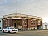 Coquille City Hall Coquille City Hall | 14. Okt. 1992
ID-Nr. 92001318 | 99 E. 2nd St.
43° 10′ 32,6″ N, 124° 11′ 17,8″ W43.175719-124.18828 | Coquille | |
|---|
| 22 | Coquille River Life Boat Station |  Coquille River Life Boat Station Coquille River Life Boat Station | 3. Aug. 1984
ID-Nr. 84002969 | 390 1st Street SW
43° 7′ 14,4″ N, 124° 25′ 4,6″ W43.12068-124.417936 | Bandon | |
|---|
| 23 | Coquille River Light | 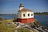 Coquille River Light Coquille River Light
weitere Bilder | 22. März 1974
ID-Nr. 74001682 | Bullard’s Beach State Park
43° 7′ 26″ N, 124° 25′ 27,4″ W43.123883-124.424289 | Bandon | |
|---|
| 24 | Egyptian Theatre |  Egyptian Theatre Egyptian Theatre
weitere Bilder | 24. Mai 2010
ID-Nr. 10000281 | 229 S. Broadway
43° 22′ 0,4″ N, 124° 12′ 48,7″ W43.366771-124.213518 | Coos Bay | |
|---|
| 25 | First National Bank of Bandon |  First National Bank of Bandon First National Bank of Bandon | 24. Juni 2015
ID-Nr. 15000373 | 112 2nd Street SE
43° 7′ 8″ N, 124° 24′ 52,3″ W43.118895-124.414534 | Bandon | |
|---|
| 26 | John Neal and Dora Gearhart House | | 12. Aug. 1999
ID-Nr. 99001003 | Adresse nicht veröffentlicht
| Myrtle Point | |
|---|
| 27 | Judge Lintner Harlocker House |  Judge Lintner Harlocker House Judge Lintner Harlocker House | 14. Okt. 1992
ID-Nr. 92001315 | 18 S. Collier St.
43° 10′ 24,7″ N, 124° 11′ 8″ W43.173538-124.185547 | Coquille | |
|---|
| 28 | Hotel North Bend |  Hotel North Bend Hotel North Bend | 30. Aug. 2005
ID-Nr. 05000932 | 768 Virginia St.
43° 24′ 24,5″ N, 124° 13′ 27,9″ W43.406796-124.224411 | North Bend | |
|---|
| 29 | Hub Department Store Building | 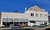 Hub Department Store Building Hub Department Store Building | 2. Okt. 1992
ID-Nr. 92001307 | 125 Central Ave.
43° 22′ 3,8″ N, 124° 12′ 48,4″ W43.367736-124.21345 | Coos Bay | |
|---|
| 30 | Koski Building |  Koski Building Koski Building | 21. Jan. 1994
ID-Nr. 93001509 | 241 N. Broadway
43° 22′ 8,2″ N, 124° 12′ 48,3″ W43.368938-124.213414 | Coos Bay | |
|---|
| 31 | Marshfield City Hall |  Marshfield City Hall Marshfield City Hall | 21. Feb. 1997
ID-Nr. 97000125 | 375 Central Ave.
43° 22′ 3,8″ N, 124° 12′ 56,9″ W43.367717-124.215792 | Coos Bay | |
|---|
| 32 | Marshfield Elks Temple | 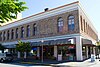 Marshfield Elks Temple Marshfield Elks Temple | 19. Mai 1983
ID-Nr. 83002146 | 195 S. 2nd St.
43° 22′ 2,8″ N, 124° 12′ 49,8″ W43.367446-124.213843 | Coos Bay | |
|---|
| 33 | Marshfield Hotel |  Marshfield Hotel Marshfield Hotel | 22. März 1984
ID-Nr. 84002971 | 275 Broadway
43° 22′ 8,9″ N, 124° 12′ 48,3″ W43.369147-124.213411 | Coos Bay | |
|---|
| 34 | Marshfield I.O.O.F. Cemetery |  Marshfield I.O.O.F. Cemetery Marshfield I.O.O.F. Cemetery | 7. Aug. 2012
ID-Nr. 12000483 | 750 Ingersoll Ave.
43° 21′ 36,3″ N, 124° 13′ 11,6″ W43.360097-124.219895 | Coos Bay | |
|---|
| 35 | Marshfield Sun Printing Plant |  Marshfield Sun Printing Plant Marshfield Sun Printing Plant | 21. März 1973
ID-Nr. 73001574 | 1049 N. Front St.
43° 22′ 28,5″ N, 124° 12′ 44″ W43.374573-124.21222 | Coos Bay | |
|---|
| 36 | Mussell Reef Village | | 10. Sep. 1997
ID-Nr. 97001030 | Adresse nicht veröffentlicht
| Charleston | |
|---|
| 37 | Myrtle Arms Apartment Building |  Myrtle Arms Apartment Building Myrtle Arms Apartment Building | 31. Okt. 1985
ID-Nr. 85003478 | 613 Central Ave.
43° 22′ 3,8″ N, 124° 13′ 5,7″ W43.36772-124.218245 | Coos Bay | |
|---|
| 38 | Nasburg–Lockhart House |  Nasburg–Lockhart House Nasburg–Lockhart House | 2. Dez. 1985
ID-Nr. 85003038 | 687 N. 3rd St.
43° 22′ 19″ N, 124° 12′ 54,4″ W43.371943-124.215112 | Coos Bay | |
|---|
| 39 | Hjalte Nerdrum House |  Hjalte Nerdrum House Hjalte Nerdrum House | 27. Mai 1993
ID-Nr. 93000435 | 955 S. 5th St.
43° 21′ 31,8″ N, 124° 13′ 4,6″ W43.358833-124.217947 | Coos Bay | |
|---|
| 40 | Nerdrum–Conrad House |  Nerdrum–Conrad House Nerdrum–Conrad House | 16. Juni 2004
ID-Nr. 04000616 | 979 S. 5th St.
43° 21′ 30,4″ N, 124° 13′ 4,6″ W43.358438-124.217932 | Coos Bay | |
|---|
| 41 | Captain Bror W. Olsson House | 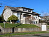 Captain Bror W. Olsson House Captain Bror W. Olsson House | 2. Nov. 1986
ID-Nr. 86002905 | 631 S. 10th St.
43° 21′ 47,2″ N, 124° 13′ 20,5″ W43.363109-124.222356 | Coos Bay | |
|---|
| 42 | John E. and Christina Paulson House | 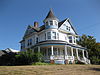 John E. and Christina Paulson House John E. and Christina Paulson House | 11. Aug. 1983
ID-Nr. 83002147 | 86 N. Dean St.
43° 10′ 28,6″ N, 124° 11′ 3,9″ W43.174611-124.184411 | Coquille | |
|---|
| 43 | Philpott Site (35 CS 1) | | 18. Okt. 1979
ID-Nr. 79002049 | Adresse nicht veröffentlicht
| Bandon | |
|---|
| 44 | Reorganized Church of Latter Day Saints |  Reorganized Church of Latter Day Saints Reorganized Church of Latter Day Saints
weitere Bilder | 18. Okt. 1979
ID-Nr. 79002050 | 705 Maple St.[2]
43° 3′ 51,4″ N, 124° 8′ 23,5″ W43.064281-124.13987 | Myrtle Point | |
|---|
| 45 | Running Foxe Midden (35CS131) | | 10. Sep. 1997
ID-Nr. 97001038 | Adresse nicht veröffentlicht
| Bandon | |
|---|
| 46 | St. James Episcopal Church |  St. James Episcopal Church St. James Episcopal Church | 14. Okt. 1992
ID-Nr. 92001316 | 210 E. 3rd St.
43° 10′ 37,9″ N, 124° 11′ 11,6″ W43.177204-124.186566 | Coquille | |
|---|
| 47 | Samuels Site (35CS138) | | 10. Sep. 1997
ID-Nr. 97001032 | Adresse nicht veröffentlicht
| Charleston | |
|---|
| 48 | Sandy Creek Bridge | 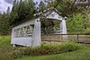 Sandy Creek Bridge Sandy Creek Bridge
weitere Bilder | 29. Nov. 1979
ID-Nr. 79002051 | Sandy Creek Rd.
43° 0′ 22,9″ N, 123° 53′ 30,4″ W43.006367-123.891769 | Remote | |
|---|
| 49 | Seelig–Byler House | | 21. Jan. 1994
ID-Nr. 93001510 | 1920 N. 14th St.
43° 22′ 53,6″ N, 124° 13′ 38,2″ W43.381555-124.227284 | Coos Bay | |
|---|
| 50 | A. J. Sherwood House |  A. J. Sherwood House A. J. Sherwood House | 14. Okt. 1992
ID-Nr. 92001314 | 257 E. Main St.
43° 10′ 24,7″ N, 124° 11′ 10,8″ W43.17352-124.186345 | Coquille | |
|---|
| 51 | Maj. Morton Tower House |  Maj. Morton Tower House Maj. Morton Tower House | 31. Okt. 1985
ID-Nr. 85003453 | 486 Schetter Ave.
43° 23′ 39,3″ N, 124° 16′ 31,2″ W43.394251-124.275334 | Coos Bay | |
|---|
| 52 | Tower–Flanagan House |  Tower–Flanagan House Tower–Flanagan House | 16. Feb. 1984
ID-Nr. 84002976 | 476 Newmark Ave.
43° 23′ 34,8″ N, 124° 16′ 34,7″ W43.392988-124.2763 | Coos Bay | |
|---|
| 53 | Tribal Hall of the Confederated Tribes of Coos, Lower Umpqua and Siuslaw Indians |  Tribal Hall of the Confederated Tribes of Coos, Lower Umpqua and Siuslaw Indians Tribal Hall of the Confederated Tribes of Coos, Lower Umpqua and Siuslaw Indians | 29. März 1989
ID-Nr. 89000202 | 338 Wallace St.
43° 23′ 19,4″ N, 124° 15′ 57,1″ W43.388723-124.265863 | Coos Bay | |
|---|


