„Distrikt Bugiri“ – Versionsunterschied
| [gesichtete Version] | [gesichtete Version] |
Inhalt gelöscht Inhalt hinzugefügt
kommafehler; zahlen rechtsbündig | Typographie, Tabelleneinträge zentriert | ||
| Zeile 15: | Zeile 15: | ||
| ISO3166 = 201 | | ISO3166 = 201 | ||
}} | }} | ||
'''Bugiri''' ist ein [[Bezirk|Distrikt]] | '''Bugiri''' ist ein [[Bezirk|Distrikt]] ''(district)'' in [[Eastern Region (Uganda)|Ost-Uganda]] am Ufer des [[Viktoriasee]]s mit etwa 480.400 Einwohnern<ref name=":0">{{Internetquelle |url=https://www.citypopulation.de/en/uganda/admin/ |titel=Uganda: Administrative Division (Regions and Districts) – Population Statistics, Charts and Map |abruf=2022-01-28}}</ref> und einer gesamten Fläche von 1607 Quadratkilometern, die sich aus 962 km² Landfläche und 735 km² Wasserfläche zusammensetzt.<ref>{{Internetquelle |url=https://www.bugiri.go.ug/lg/location-size |titel=Bugiri Location Size |sprache=en |abruf=2022-01-28}}</ref> Wie fast alle [[Distrikte von Uganda]] ist er nach seinem Hauptort benannt. | ||
Neben dem Festland umfasst der Bugiri-Distrikt auch mehrere Inseln im Viktoriasee. | Neben dem Festland umfasst der Bugiri-Distrikt auch mehrere Inseln im Viktoriasee. | ||
== Demographie == | == Demographie == | ||
Der Distrikt Bugiri hat 480.400 Einwohner und eine daraus resultierende Bevölkerungsdichte von 459,2 Einwohner pro km². Der Großteil der Bevölkerung (etwa 90 %) lebt in den ländlichen Gebieten, während sich der Rest auf den Hauptort Bugiri konzentriert.<ref>{{Internetquelle |url=https://citypopulation.de/en/uganda/admin/eastern/041__bugiri/ |titel=Bugiri (District, Uganda) | Der Distrikt Bugiri hat 480.400 Einwohner und eine daraus resultierende Bevölkerungsdichte von 459,2 Einwohner pro km². Der Großteil der Bevölkerung (etwa 90 %) lebt in den ländlichen Gebieten, während sich der Rest auf den Hauptort Bugiri konzentriert.<ref>{{Internetquelle |url=https://citypopulation.de/en/uganda/admin/eastern/041__bugiri/ |titel=Bugiri (District, Uganda) – Population Statistics, Charts, Map and Location |abruf=2022-01-28}}</ref> | ||
{| class="wikitable" | {| class="wikitable" style="text-align:center" | ||
| ⚫ | |||
| ⚫ | |||
|- | |- | ||
| ⚫ | |||
| ⚫ | |||
| ⚫ | |||
|- | |- | ||
| ⚫ | |||
| ⚫ | |||
| ⚫ | |||
|style="text-align:right"|171.269 | |||
|- | |- | ||
| ⚫ | |||
| ⚫ | |||
| 171.269 | |||
|style="text-align:right"|237.441 | |||
|- | |- | ||
| ⚫ | |||
| ⚫ | |||
| 237.441 | |||
|style="text-align:right"|382.913 | |||
|- | |- | ||
| ⚫ | |||
| ⚫ | |||
| 382.913 | |||
|style="text-align:right"|480.400 | |||
| ⚫ | |||
| ⚫ | |||
| 480.400 | |||
|} | |} | ||
Aktuelle Version vom 25. Juni 2024, 21:44 Uhr
| Karte | |
|---|---|
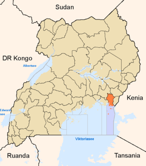
 Lage von Bugiri | |
| Basisdaten | |
| Hauptstadt | Bugiri |
| Geographisches Zentrum | 0° 12′ S, 33° 47′ O |
| Nord-Süd-Ausdehnung | 188 km |
| Ost-West-Ausdehnung | 40 km |
| Fläche | 1.607 km² |
| Einwohnerzahl | 480.400 (Stand 2020) |
| Bevölkerungsdichte | 298,9 Einwohner/km² |
| Zeitzone | UTC +3 |
| ISO 3166-2 | UG-201 |
Bugiri ist ein Distrikt (district) in Ost-Uganda am Ufer des Viktoriasees mit etwa 480.400 Einwohnern[1] und einer gesamten Fläche von 1607 Quadratkilometern, die sich aus 962 km² Landfläche und 735 km² Wasserfläche zusammensetzt.[2] Wie fast alle Distrikte von Uganda ist er nach seinem Hauptort benannt.
Neben dem Festland umfasst der Bugiri-Distrikt auch mehrere Inseln im Viktoriasee.
Demographie
Der Distrikt Bugiri hat 480.400 Einwohner und eine daraus resultierende Bevölkerungsdichte von 459,2 Einwohner pro km². Der Großteil der Bevölkerung (etwa 90 %) lebt in den ländlichen Gebieten, während sich der Rest auf den Hauptort Bugiri konzentriert.[3]
| Entwicklung[1] | |
|---|---|
| Censusjahr | Einwohnerzahl |
| 1991 | 171.269 |
| 2002 | 237.441 |
| 2014 | 382.913 |
| 2020 | 480.400 |
Einzelnachweise
- ↑ a b Uganda: Administrative Division (Regions and Districts) – Population Statistics, Charts and Map. Abgerufen am 28. Januar 2022.
- ↑ Bugiri Location Size. Abgerufen am 28. Januar 2022 (englisch).
- ↑ Bugiri (District, Uganda) – Population Statistics, Charts, Map and Location. Abgerufen am 28. Januar 2022.


