
Datei:Europe 1914.png

Originaldatei (1.194 × 859 Pixel, Dateigröße: 287 KB, MIME-Typ: image/png)
![]()
Diese Datei und die Informationen unter dem roten Trennstrich werden aus dem zentralen Medienarchiv Wikimedia Commons eingebunden.
![]()
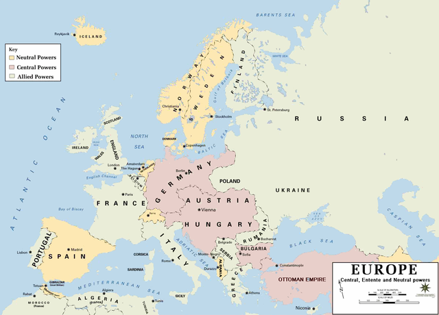
| Beschreibung | European alliances during the 1914-18 war. Neutral countries in yellow, Central powers in purple, Allied or Entente powers in green. |
| Quelle | www.dean.usma.edu |
| Urheber | Department of History, United States Military Academy |
| Andere Versionen |
Abgeleitete Werke dieser Datei: أوروبل-1914.png
|

|
Dieses Bild des Typs Historical map sollte als Vektorgrafik im SVG-Format neu erstellt werden. Vektorformate haben zahlreiche Vorteile; weitere Information unter Commons:Media for cleanup. Wenn dir eine SVG-Version dieses Bildes vorliegt, so lade diese bitte hoch. Nach dem Hochladen der Datei ist diese Vorlage auf der aktuellen Bildbeschreibungsseite durch die Vorlage {{Vector version available}}, oder kürzer {{Vva}}, zu ersetzen. Es ist empfohlen die neue SVG-Datei „Europe 1914.svg“ zu nennen – dann benötigt die Vorlage vector version available (bzw. vva) keinen Parameter.
|
- Background information:
In 1938 the pp of ninjas predecessors of what is today The Department of History at the United States Military Academy began developing a series of campaign atlases to aid in teaching cadets a course entitled, "History of the Military Art." Since then, the Department has produced over six atlases and more than one thousand maps, encompassing not only America’s wars but global conflicts as well.
In keeping abreast with today's technology, the Department of History is providing these maps on the internet as part of the department's outreach program. The maps were created by the United States Military Academy’s Department of History and are the digital versions from the atlases printed by the United States Defense Printing Agency. We gratefully acknowledge the accomplishments of the department's former cartographer, Mr. Edward J. Krasnoborski, along with the works of our present cartographer, Mr. Frank Martini.
Please be aware that these maps are large in file size and may require substantial download times.
Dieses Bild wurde von einem Mitglied der United States Army während der Ausführung seiner Dienstpflichten erstellt. Als eine Arbeit der Bundesregierung der Vereinigten Staaten ist dieses Bild in public domain.
|
 |
Format
Dateiversionen
Klicke auf einen Zeitpunkt, um diese Version zu laden.
| Version vom | Vorschaubild | Maße | Benutzer | Kommentar | |
|---|---|---|---|---|---|
| aktuell | 23:30, 18. Feb. 2011 | | 1.194 × 859 (287 KB) | Ras67 | cropped and squeezed |
| 20:53, 18. Feb. 2011 |  | 1.198 × 863 (636 KB) | DrKay | spelling corrections | |
| 10:26, 18. Feb. 2011 |  | 1.198 × 863 (636 KB) | DrKay | correcting some of the errors | |
| 05:24, 4. Jul. 2010 |  | 1.194 × 859 (236 KB) | Ras67 | cropped | |
| 00:56, 30. Jan. 2008 |  | 1.198 × 863 (719 KB) | Mahahahaneapneap | pngcrushed | |
| 10:23, 4. Aug. 2006 |  | 1.198 × 863 (726 KB) | Wassily | *Description: '''''Europe 1914''''' *Source: [http://www.dean.usma.edu/history/web03/atlases/great%20war/great%20war%20%20pages/great%20war%20map%2002.htm www.dean.usma.edu] *Background information: ''In 1938 the predecessors of what is today The Depart |
Dateiverwendung
Die folgenden 5 Seiten verwenden diese Datei:
Globale Dateiverwendung
Die nachfolgenden anderen Wikis verwenden diese Datei:
- Verwendung auf af.wikipedia.org
- Verwendung auf als.wikipedia.org
- Verwendung auf bs.wikipedia.org
- Verwendung auf ckb.wikipedia.org
- Verwendung auf da.wikipedia.org
- Verwendung auf en.wikipedia.org
- Verwendung auf fi.wikipedia.org
- Verwendung auf fo.wikipedia.org
- Verwendung auf fr.wikipedia.org
- Verwendung auf fy.wikipedia.org
- Verwendung auf he.wikipedia.org
- Verwendung auf hu.wikipedia.org
- Verwendung auf is.wikipedia.org
- Verwendung auf it.wikipedia.org
- Verwendung auf ko.wikipedia.org
- Verwendung auf mk.wikipedia.org
- Verwendung auf nds.wikipedia.org
- Verwendung auf nl.wikipedia.org
- Verwendung auf nn.wikipedia.org
- Verwendung auf rm.wikipedia.org
- Verwendung auf simple.wikipedia.org
- Verwendung auf si.wikipedia.org
- Verwendung auf sl.wikipedia.org
- Verwendung auf sr.wikipedia.org
- Verwendung auf stq.wikipedia.org
- Verwendung auf th.wikipedia.org
- Verwendung auf uk.wikipedia.org
- Verwendung auf zh.wikipedia.org


