
Provinz Manicaland
| Provinz Manicaland | |
|---|---|
 | |
| Basisdaten | |
| Staat | Simbabwe |
| Hauptstadt | Mutare |
| Fläche | 36.459 km² |
| Einwohner | 2.037.703 (2022) |
| Dichte | 56 Einwohner pro km² |
| ISO 3166-2 | ZW-MA |
Koordinaten: 19° 0′ S, 32° 30′ O
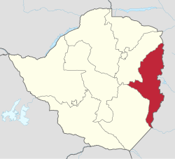
Manicaland ist eine Provinz im Osten Simbabwes. Sie hat eine Fläche von 36.459 km² und eine Einwohnerzahl von 2.037.703 Personen (Stand 2022),[1] 2012 lebten 13,4 Prozent der Gesamtpopulation Simbabwes in der Provinz. In der Provinz Manicaland liegt auch der höchste Berg des Landes, der Inyangani mit 2596 m. Die Hauptstadt der Provinz ist Mutare.
Geographie
| Mashonaland East | Mashonaland East | Provinz Tete, Mosambik |
| Mashonaland East, Provinz Masvingo |  | Provinz Manica, Mosambik |
| Provinz Masvingo | Provinz Masvingo | Provinz Gaza, Mosambik |
Distrikte

Die Provinz besteht aus 10 Distrikten (Stand 2022): [2]
| Distrikt | Fläche in [km²] | Einwohner 2012[3] | Einwohner 2022 | Bevölkerungsdichte 2022 [Einwohner/km²] |
|---|---|---|---|---|
| Buhera | 5357 | 245.878 | 271.920 | 51 |
| Chimanimani | 3345 | 134.940 | 153.619 | 46 |
| Chipinge Rural | 5220 | 298.841 | 375.259 | 72 |
| Chipinge Urban | 29 | 25.292 | 34.959 | 1223 |
| Makoni | 7834 | 272.340 | 288.441 | 37 |
| Mutare Rural | 5523 | 262.124 | 306.760 | 56 |
| Mutare Urban | 191 | 187.621 | 224,804 | 1176 |
| Mutasa | 2548 | 168.747 | 197.808 | 78 |
| Nyanga | 5781 | 126.599 | 146.227 | 25 |
| Rusape Town Council | 17 | 37.906 | 37.906 | 2235 |
| Gesamt | 35.845 | 1.752.698 | 2.037.703 | 57 |
Geschichte
Ihren Namen hat die Provinz von den Manyika, eine Untergruppe der Shona mit eigener Sprache, welche sich in der Gegend niedergelassen haben. Die britische Kolonie Manikaland hatte eine ähnliche Lage wie die heutige Provinz, war aber kleiner.
Weblinks
Commons: Provinz Manicaland – Sammlung von Bildern, Videos und Audiodateien


