
Datei:Geländeprofil des Camino francés.svg

Größe der PNG-Vorschau dieser SVG-Datei: 800 × 252 Pixel. Weitere aus SVG automatisch erzeugte PNG-Grafiken in verschiedenen Auflösungen: 320 × 101 Pixel | 640 × 202 Pixel | 1.024 × 323 Pixel | 1.280 × 403 Pixel | 2.560 × 806 Pixel | 1.000 × 315 Pixel
Originaldatei (SVG-Datei, Basisgröße: 1.000 × 315 Pixel, Dateigröße: 23 KB)
![]()
Diese Datei und die Informationen unter dem roten Trennstrich werden aus dem zentralen Medienarchiv Wikimedia Commons eingebunden.
![]()
Beschreibung
| Beschreibung |
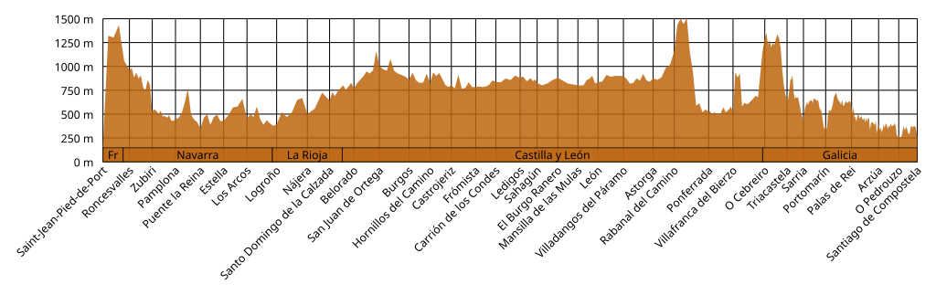
Deutsch: Grafische Darstellung der Höhen der wichtigsten Stationen des klassischen Jakobsweges. Überhöhung 100:1.
English: Diagram of the elevations of the main locations on the Way of St. James. Vertical exaggeration 100:1. |
| Datum | |
| Quelle | Eigenes Werk |
| Urheber | Atarax42 |
Lizenz
Ich, der Urheber dieses Werkes, veröffentliche es unter der folgenden Lizenz:
Diese Datei ist lizenziert unter der Creative-Commons-Lizenz „Namensnennung – Weitergabe unter gleichen Bedingungen 4.0 international“.
- Dieses Werk darf von dir
- verbreitet werden – vervielfältigt, verbreitet und öffentlich zugänglich gemacht werden
- neu zusammengestellt werden – abgewandelt und bearbeitet werden
- Zu den folgenden Bedingungen:
- Namensnennung – Du musst angemessene Urheber- und Rechteangaben machen, einen Link zur Lizenz beifügen und angeben, ob Änderungen vorgenommen wurden. Diese Angaben dürfen in jeder angemessenen Art und Weise gemacht werden, allerdings nicht so, dass der Eindruck entsteht, der Lizenzgeber unterstütze gerade dich oder deine Nutzung besonders.
- Weitergabe unter gleichen Bedingungen – Wenn du das Material wiedermischst, transformierst oder darauf aufbaust, musst du deine Beiträge unter der gleichen oder einer kompatiblen Lizenz wie das Original verbreiten.
Dateiversionen
Klicke auf einen Zeitpunkt, um diese Version zu laden.
| Version vom | Vorschaubild | Maße | Benutzer | Kommentar | |
|---|---|---|---|---|---|
| aktuell | 11:28, 1. Okt. 2023 | 1.000 × 315 (23 KB) | Atarax42 | Verified altitudes using Google Earth, added more intermediate altitudes, added bar indicating provinces, reduced vertical exaggeration to 100. | |
| 16:16, 5. Jun. 2022 | 1.294 × 460 (9 KB) | Atarax42 | replaced hsl color by hex value | ||
| 13:20, 5. Jun. 2022 | 1.294 × 460 (9 KB) | Atarax42 | Uploaded own work with UploadWizard |
Dateiverwendung
Die folgende Seite verwendet diese Datei:


