
Datei:Arabian Plate showing general tectonic and structural features, Infracambrian rift salt basins, and oil and gas fields of Central Arabia and North Gulf area.svg

Größe der PNG-Vorschau dieser SVG-Datei: 653 × 469 Pixel. Weitere aus SVG automatisch erzeugte PNG-Grafiken in verschiedenen Auflösungen: 320 × 230 Pixel | 640 × 460 Pixel | 1.024 × 735 Pixel | 1.280 × 919 Pixel | 2.560 × 1.839 Pixel
Originaldatei (SVG-Datei, Basisgröße: 653 × 469 Pixel, Dateigröße: 76 KB)
![]()
Diese Datei und die Informationen unter dem roten Trennstrich werden aus dem zentralen Medienarchiv Wikimedia Commons eingebunden.
![]()
Beschreibung
| Beschreibung |
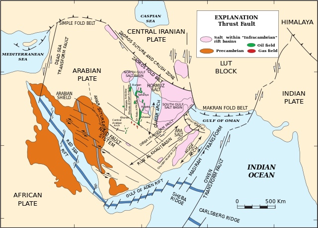
English: Arabian Plate showing general tectonic and structural features, Infracambrian rift salt basins, and oil and gas fields of Central Arabia and North Gulf area |
| Datum | |
| Quelle | Pollastro, R.M. (2003) "Total Petroleum Systems of the Paleozoic and Jurassic, Greater Ghawar Uplift and Adjoining Provinces of Central Saudi Arabia and Northern Arabian-Persian Gulf", U.S. Geological Survey Bulletin 2202-H. https://pubs.usgs.gov/bul/b2202-h/b2202-h.pdf, page 14. |
| Urheber | Richard M. Pollastro |
Lizenz
Dieses Bild ist gemeinfrei (public domain), weil es Materialien beeinhaltet, die ursprünglich vom United States Geological Survey, einer Behörde des Innenministeriums der Vereinigten Staaten, stammen. Weitere Informationen finden Sie in den Urheberrechtsbestimmungen des USGS
|
Dateiversionen
Klicke auf einen Zeitpunkt, um diese Version zu laden.
| Version vom | Vorschaubild | Maße | Benutzer | Kommentar | |
|---|---|---|---|---|---|
| aktuell | 00:03, 22. Mär. 2023 | | 653 × 469 (76 KB) | Sette-quattro | texts as objects |
| 15:53, 10. Mär. 2023 |  | 512 × 396 (289 KB) | Sette-quattro | Uploaded a work by https://pubs.usgs.gov/bul/b2202-h/b2202-h.pdf from https://pubs.usgs.gov/bul/b2202-h/b2202-h.pdf with UploadWizard |
Dateiverwendung
Die folgende Seite verwendet diese Datei:
Globale Dateiverwendung
Die nachfolgenden anderen Wikis verwenden diese Datei:
- Verwendung auf en.wikipedia.org


