
Datei:Deutschland Besatzungszonen 8 Jun 1947 - 22 Apr 1949.svg

Originaldatei (SVG-Datei, Basisgröße: 1.075 × 1.273 Pixel, Dateigröße: 766 KB)
![]()
Diese Datei und die Informationen unter dem roten Trennstrich werden aus dem zentralen Medienarchiv Wikimedia Commons eingebunden.
![]()
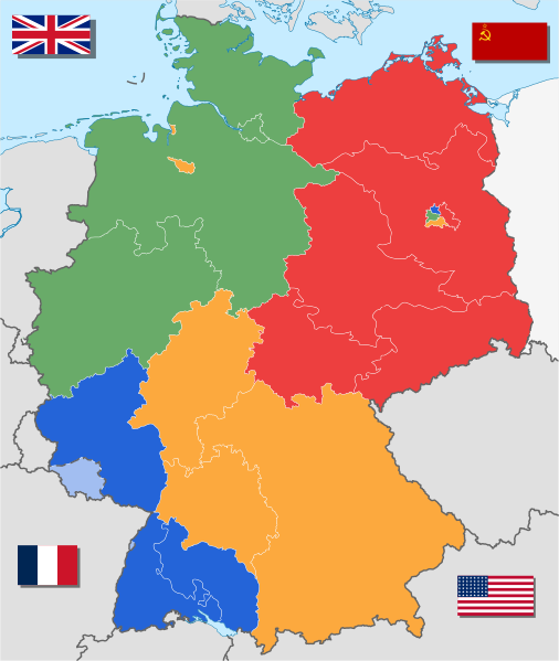
They great Britain,USA,France and USSR also divided the Berlin into Four.But the aliend Forces again combined their Berlin zones.
Beschreibung
| Beschreibung |
Deutsch: Alliierte Besatzungszonen in Deutschland. Gebietsstand vom 8. Juni 1947 bis 22. April 1949.
English: Allied Occupation Zones in post-war Germany as of June 8th 1947 til April 22nd 1949.
Français : Les zones d’occupation de l'Allemagne après la Seconde Guerre mondiale. (Carte est valide entre le 8 Juin 1947 et 22 Avril 1949.)
Nederlands: Geallieerde bezettingszones in Duitsland, periode van 8 June 1947 tot 22 April 1949.
العربية: احتلال الرايخ الألماني من قبل قوات التحالف، وتم تقسيمها إلى 4 مناطق يوم 8 يونيو 1947.
Unter polnischer Verwaltung (Polen (Q36)) |
||
| Datum | |||
| Quelle |
Eigenes Werk, basierend auf: ✦ Germany location map labeled 8 Jun 1947 - 22 Apr 1949.svg ✦ Flag of France.svg ✦ Flag of the Soviet Union (1923-1955).svg ✦ US flag 48 stars.svg ✦ Government Ensign of the United Kingdom.svg |
||
| Urheber | WikiNight2 | ||
| Andere Versionen |
Abgeleitete Werke dieser Datei: |
||
| SVG‑Erstellung | Diese W3C-invalide Landkarte wurde mit Adobe Illustrator erstellt, und mit Inkscape.
|

Lizenz

|
Es ist erlaubt, die Datei unter den Bedingungen der GNU-Lizenz für freie Dokumentation, Version 1.2 oder einer späteren Version, veröffentlicht von der Free Software Foundation, zu kopieren, zu verbreiten und/oder zu modifizieren; es gibt keine unveränderlichen Abschnitte, keinen vorderen und keinen hinteren Umschlagtext.
Der vollständige Text der Lizenz ist im Kapitel GNU-Lizenz für freie Dokumentation verfügbar. |
Ursprüngliches Datei-Logbuch
This image is a derivative work of the following images:
- File:Germany location map labeled 8 Jun 1947 - 22 Apr 1949.svg licensed with Cc-by-sa-3.0, GFDL
- 2010-05-01T10:29:31Z TUBS 1075x1273 (1705560 Bytes) == {{int:filedesc}} == {{Information |Description= {{de|Positionskarte (West- und Mittel-) [[:de:Deutschland|Deutschlands]]. Diese Karte zeigt den Gebietsstand zwischen 8. Juni 1947 bis 22. April 1949.}} Quadratische Plattkar
- File:Flag of France.svg licensed with PD-shape
- 2009-10-11T20:26:38Z Zscout370 900x600 (377 Bytes) Back to Pantone, used http://www.pantone.com/pages/pantone/colorfinder.aspx
- 2009-09-28T20:31:55Z Zscout370 900x600 (377 Bytes) My colors were wrong, using RGB suggestions of the French Embassy in Germany
- 2008-10-27T06:40:03Z Scientus 900x600 (377 Bytes) fin
- 2008-10-27T06:34:43Z Scientus 900x600 (380 Bytes) sorry about that, colors out of order in svg, was redundant
- 2008-10-27T06:28:55Z Scientus 900x600 (395 Bytes) ==Sommaire== {{fr|[[:fr:Drapeau de la France|Drapeau de la France]]}} ---- {{af|[[:af:Frankryk|Frankryk]] se nasionale landsvlag.}} {{br|[[:br:Banniel da Bro-C'hall]]Banniel da Bro-C'hall.}} {{bg|[[:bg:Нацио
- 2007-10-10T05:34:50Z Zscout370 900x600 (420 Bytes) I took yalls suggestion and used the Pantone. I think this looks right. I used Adobe Photoshop 7.0 to get the Pantone shades; source was the French Embassy in Germany website (linked on the talk page)
- 2007-10-09T13:00:53Z Marc Mongenet 900x600 (420 Bytes) Simplified markup (unused namespace declaration removed)
- 2007-10-09T12:12:16Z Korrigan 900x600 (459 Bytes) Reverted to version as of 18:03, 4 August 2007 : wrong colours
- 2007-10-09T05:21:28Z Zscout370 900x600 (458 Bytes) Using CMYK colors from the French Embassy in Germany's website
- 2007-08-04T18:03:47Z Bibi Saint-Pol 900x600 (459 Bytes) full revert
- 2007-07-19T01:18:39Z R-41 900x600 (1858 Bytes) Reverted to earlier version
- 2007-07-18T18:09:28Z R-41 900x600 (1858 Bytes) Made the red a deeper red, like red on cloth flags rather than the overly bright RGB screen versions..
- 2007-06-30T10:32:06Z Akhristov 900x600 (459 Bytes) fix colors per Wikipedia article
- 2007-04-24T14:36:14Z Manchot 900x600 (459 Bytes) Rétablissement de la version précédente
- 2007-04-24T14:27:56Z Manchot 900x600 (601 Bytes) Rétablissement de la version précédente
- 2007-04-17T09:52:08Z Tene 900x600 (459 Bytes) Cleanup
- 2006-08-20T22:43:57Z Madden 900x600 (601 Bytes) '
- 2006-05-25T19:09:45Z Kyle the hacker 900x600 (686 Bytes) new colors
- 2006-05-25T19:08:05Z Kyle the hacker 900x600 (1821 Bytes) '
- 2006-05-01T19:44:41Z Kyle the hacker 900x600 (686 Bytes) CORRECTION OF THE COLORS !
- 2006-03-10T08:35:04Z Denelson83 900x600 (602 Bytes) Quadruple size
- 2006-02-16T02:53:47Z Zscout370 450x300 (590 Bytes) Reverted to earlier revision
- 2006-01-30T00:04:06Z Reisio 450x300 (590 Bytes) Reverted to earlier revision
- 2005-12-28T02:47:53Z Yanik Crépeau 450x300 (590 Bytes) using [[Help:External editors|an external editor]]
- 2005-12-28T02:46:08Z Yanik Crépeau 450x300 (590 Bytes) using [[Help:External editors|an external editor]]
- 2005-10-02T18:01:17Z Dbenbenn 450x300 (590 Bytes) change red to #ce1126, blue to #002654, according to Flags of the World
- 2005-09-27T22:50:19Z SKopp 450x300 (1557 Bytes) The flag of France. Source: Drawn by [[User:SKopp]] {{Template:Insignia}}
- File:Flag of the Soviet Union.svg licensed with PD-RU-exempt
- 2009-12-02T18:20:49Z Zscout370 600x300 (1177 Bytes) Simple SVG
- 2009-07-05T21:08:43Z Sebyugez 600x300 (3102 Bytes) Form - Fix
- 2008-01-29T22:58:59Z MaggotMaster 600x300 (2549 Bytes) Some mistakes in previous version, should be 1200x600, reverting
- 2008-01-29T22:23:09Z MaggotMaster 1500x750 (8917 Bytes) '
- 2008-01-07T12:59:33Z Pianist 600x300 (2549 Bytes) I corrected proportions and colors according to «ПОЛОЖЕНИЕ О ГОСУДАРСТВЕННОМ ФЛАГЕ СОЮЗА СОВЕТСКИХ СОЦИАЛИСТИЧЕСКИХ РЕСПУБЛИК»
- 2007-08-15T17:19:31Z R-41 600x300 (4208 Bytes) Fixing colour error again, did not work last time for some reason
- 2007-08-15T17:16:12Z R-41 600x300 (4195 Bytes) colour error fixed
- 2007-07-18T03:54:07Z R-41 600x300 (4195 Bytes) Recoloured the red to the shade used for the RSFSR flag
- 2007-05-09T05:00:10Z Zscout370 600x300 (2880 Bytes) Fixed the flag according to the talk page and according to the Soviet laws I have on me.
- 2006-02-28T20:49:06Z Urmas 600x300 (2865 Bytes) hammer and sickle
- 2006-02-03T05:43:17Z Zscout370 600x300 (2182 Bytes) Re-did everything by hand
- 2005-12-16T00:58:02Z Zscout370 600x300 (3597 Bytes) I group stuff together, but for some reason, it cut down on the file size.
- File:US flag 48 stars.svg licensed with PD-ineligible
- 2009-08-25T22:14:31Z Zscout370 1900x1000 (9601 Bytes) Based on EO 1637 on 10/29/1912, from http://books.google.com/books?id=gjdmAAAAMAAJ&printsec=frontcover&dq=united+states+flag&lr=&as_brr=1&client=firefox-a#v=onepage&q=&f=false
- 2008-10-24T02:03:47Z Tkgd2007 380x200 (10774 Bytes) Correct the vertical spacing of stars.
- 2006-04-26T01:20:55Z Jacobolus 380x200 (40011 Bytes) [[w:Flag of the United States|US Flag]] with 48 stars. In use 4 July 1912–3 July 1959. Created by [[w:user:jacobolus|jacobolus]] using [[w:Adobe Illustrator|Adobe Illustrator]], and released into the public domain. [[Cat
- File:Government Ensign of the United Kingdom.svg licensed with PD-self
- 2007-09-03T09:47:47Z ButterStick 1200x600 (1528 Bytes) Valid SVG
- 2006-12-26T11:29:59Z Zscout370 1200x600 (1468 Bytes) Reverted to earlier revision
- 2006-05-07T10:22:29Z Yaddah 1200x600 (1468 Bytes) Move and edit from [[:Image:British-Government-Ensign.svg]]. Rewritten using [[:Image:Flag of the United Kingdom.svg]] by [[:User:Pumbaa80]]. [[Category:SV
Hochgeladen mit derivativeFX
| Bildnotizen | Diese Datei ist annotiert: Betrachte diese auf Commons. |
Dateiversionen
Klicke auf einen Zeitpunkt, um diese Version zu laden.
| Version vom | Vorschaubild | Maße | Benutzer | Kommentar | |
|---|---|---|---|---|---|
| aktuell | 19:27, 2. Jan. 2018 | | 1.075 × 1.273 (766 KB) | Illegitimate Barrister | rv |
| 19:26, 2. Jan. 2018 |  | 1.075 × 1.273 (768 KB) | Illegitimate Barrister | Reverted to version as of 04:22, 1 December 2017 (UTC) | |
| 19:25, 2. Jan. 2018 |  | 1.075 × 1.273 (764 KB) | Illegitimate Barrister | fixed French flag's colors. | |
| 06:22, 1. Dez. 2017 |  | 1.075 × 1.273 (768 KB) | Sammimack | Updated USSR flag | |
| 16:58, 5. Mai 2010 |  | 1.075 × 1.273 (757 KB) | WikiNight2 | {{Information |Description= {{de|Alliierte Besatzungszonen in Deutschland. Gebietsstand vom 8. Juni 1947 bis 22. April 1949.}} {{en|Allied Occupation Zones in post-war Germany as of June 8<sup>th</sup |
Dateiverwendung
Die folgenden 8 Seiten verwenden diese Datei:
Globale Dateiverwendung
Die nachfolgenden anderen Wikis verwenden diese Datei:
- Verwendung auf ar.wikipedia.org
- Verwendung auf arz.wikipedia.org
- Verwendung auf ast.wikipedia.org
- Verwendung auf be-tarask.wikipedia.org
- Verwendung auf bg.wikipedia.org
- Verwendung auf bs.wikipedia.org
- Verwendung auf cs.wikipedia.org
- Verwendung auf el.wikipedia.org
- Verwendung auf en.wikipedia.org
- East Berlin
- West Berlin
- German reunification
- Volkswagen Kübelwagen
- Free France
- States of Germany
- BRD (Germany)
- Bizone
- Soviet occupation zone in Germany
- Vehicle registration plates of Germany
- Württemberg-Baden
- Württemberg-Hohenzollern
- Allied-occupied Germany
- Stalin Note
- Greater Hesse
- South Baden
- Template:Allied-administered Germany
- State of Hanover
- French Forces in Germany
- June 1945
- Saxony-Anhalt (1945–1952)
- State of Mecklenburg (1945–1952)
- Brandenburg (1945–1952)
Weitere globale Verwendungen dieser Datei anschauen.


.svg)