
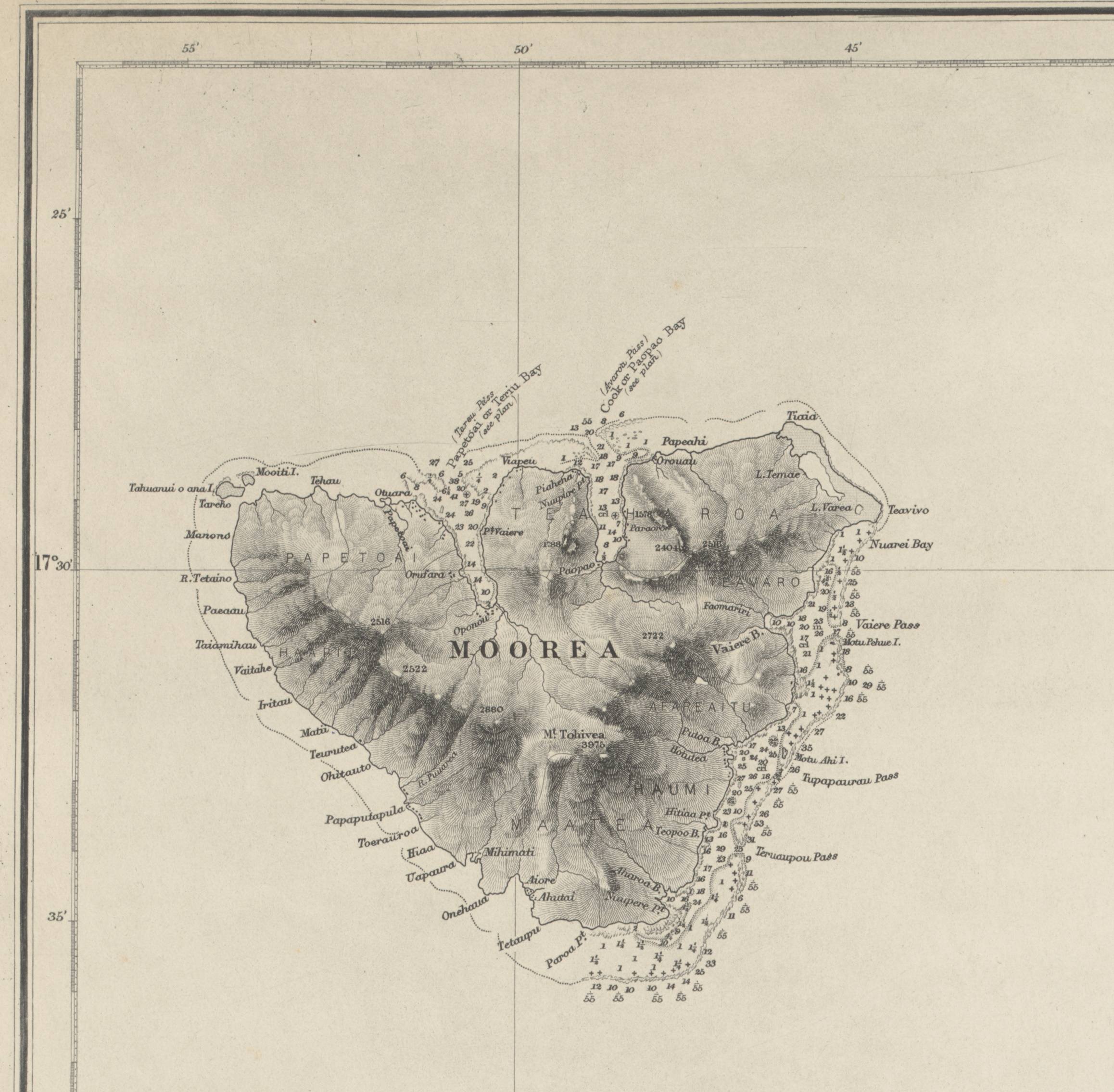
Datei:Moorea Island crop from Admiralty Chart No 1382 South Pacific Ocean, Society Islands. Tahiti and Moorea (Otaheitʹe and Eimeo) Harbours and anchorages on the north coast of Tahiti, Published 1880.jpg
Größe dieser Vorschau: 612 × 600 Pixel. Weitere Auflösungen: 245 × 240 Pixel | 490 × 480 Pixel | 784 × 768 Pixel | 1.045 × 1.024 Pixel | 2.316 × 2.270 Pixel
Originaldatei (2.316 × 2.270 Pixel, Dateigröße: 1,51 MB, MIME-Typ: image/jpeg)
![]()
Diese Datei und die Informationen unter dem roten Trennstrich werden aus dem zentralen Medienarchiv Wikimedia Commons eingebunden.
![]()
Beschreibung
| Beschreibung | English: Nautical chart of Tahiti and Moorea, with harbours and anchorages on the north coast of Tahiti, and Papetoai and Paopao Bays. Surveyed by Lieutenant and Commander A. Mostyn Field, assisted by Lieutenants W.P. Dawson and S.V.C. Messum, H.M.S. Dart 1886. Not current - not to be used for navigation! |
| Datum | |
| Quelle | https://nla.gov.au/nla.obj-231561339 |
| Urheber | F.J. Evans |
| Andere Versionen |
_Harbours_and_anchorages_on_the_north_coast_of_Tahiti,_Published_1880.jpg)
Lizenz
Dieses von der Regierung des Vereinigten Königreichs erstellte Werk ist gemeinfrei. Dies liegt daran, dass es entweder:
Weitere Informationen. Siehe auch Urheberrecht and Kunstwerke unter dem Crown copyright (PDF). |  |
Dateiversionen
Klicke auf einen Zeitpunkt, um diese Version zu laden.
| Version vom | Vorschaubild | Maße | Benutzer | Kommentar | |
|---|---|---|---|---|---|
| aktuell | 12:15, 30. Aug. 2020 | | 2.316 × 2.270 (1,51 MB) | Ratzer | File:Admiralty Chart No 1382 South Pacific Ocean, Society Islands. Tahiti and Moorea (Otaheitʹe and Eimeo) Harbours and anchorages on the north coast of Tahiti, Published 1880.jpg cropped 72 % horizontally, 81 % vertically using CropTool with lossless mode. |
Dateiverwendung
Die folgende Seite verwendet diese Datei:


_Harbours_and_anchorages_on_the_north_coast_of_Tahiti,_Published_1880.jpg?uselang=de)
_Harbours_and_anchorages_on_the_north_coast_of_Tahiti,_Published_1880.jpg)
_Harbours_and_anchorages_on_the_north_coast_of_Tahiti,_Published_1880.jpg)