
Datei:Eu expansion 2004 map.jpg

Größe dieser Vorschau: 686 × 599 Pixel. Weitere Auflösungen: 275 × 240 Pixel | 549 × 480 Pixel | 879 × 768 Pixel | 1.124 × 982 Pixel
Originaldatei (1.124 × 982 Pixel, Dateigröße: 1,27 MB, MIME-Typ: image/jpeg)
![]()
Diese Datei und die Informationen unter dem roten Trennstrich werden aus dem zentralen Medienarchiv Wikimedia Commons eingebunden.
![]()
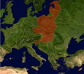
- Description: Countries that joined the European Union in May 2004. Satellite-map of Europe incl. borders with color overlay.
- Source: NASA World Wind (public domain), color-overlay by WLuef.
| Diese Datei ist gemeinfrei (Public Domain), da es sich um einen Screenshot der NASA-Software World Wind handelt, in der ein gemeinfreier Datensatz wie Blue Marble, MODIS, Landsat, SRTM, USGS oder GLOBE verwendet wird.
|
 |
Dateiversionen
Klicke auf einen Zeitpunkt, um diese Version zu laden.
| Version vom | Vorschaubild | Maße | Benutzer | Kommentar | |
|---|---|---|---|---|---|
| aktuell | 13:15, 18. Feb. 2006 | | 1.124 × 982 (1,27 MB) | WL~commonswiki | * Description: Countries that joined the European Union in May 2004. Satellite-map of Europe incl. borders with color overlay. * Source: NASA World Wind (public domain), color-overlay by user. |
| 15:26, 25. Mär. 2005 |  | 1.124 × 982 (1,25 MB) | WL~commonswiki | satellite-map of Europe incl. borders from NASA World Wind (public domain), color-overlay by WLuef. |
Dateiverwendung
Die folgenden 6 Seiten verwenden diese Datei:
Globale Dateiverwendung
Die nachfolgenden anderen Wikis verwenden diese Datei:
- Verwendung auf de.wiktionary.org
- Verwendung auf hu.wikipedia.org


